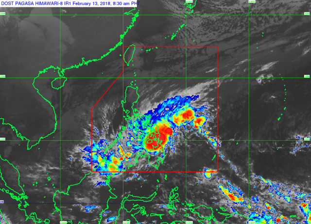
MANILA, Philippines — (UPDATE 3 – 11:47 a.m.) The weather disturbance “Basyang” weakened from a tropical storm to a tropical depression after making landfall in Cortes, Surigao del Sur mid-morning Tuesday, February 13.
With this development, the Philippine Atmospheric, Geophysical and Astronomical Services Administration lifted Tropical Cyclone Warning Signal No. 2, meaning winds of 61-120 kilometers per hour were expected in 24 hours, over several areas.
But they and several other places remained under Signal No. 1, or 30-60 kph winds in 36 hours. These areas are:
- Palawan including Calamian and Cuyo groups of islands
- Aklan
- Capiz
- Antique
- Iloilo
- Guimaras
- Negros Occidental
- Negros Oriental
- Siquijor
- Bohol
- Cebu
- Biliran
- Leyte
- Southern Leyte
- Southern section of Samar
- Southern section of Eastern Samar
- Dinagat Islands
- Surigao del Norte
- Surigao del Sur
- Agusan del Norte
- Agusan del Sur
- Camiguin
- Misamis Oriental
- Northern section of Bukidnon
- Lanao del Norte
- Northern section of Lanao del Sur
- Misamis Occidental
- Northern section of Zamboanga del Norte
Basyang was last tracked at 10 a.m. in the vicinity of Cantilan, Surigao del Sur with maximum sustained winds of 55 kph with gusts of up to 75 kph as it moved west-northwest at 25 kph.
Pagasa forecast scattered to widespread moderate to heavy rains over the next 24 hours in Palawan, the Visayas, Caraga, Northern Mindanao and Zamboanga Peninsula.
Scattered light to moderate, with at times heavy, rains are expected over the Bicol region and the rest of Mimaropa and Mindanao.
Despite the downgrade in its warning, Pagasa urged people to take the appropriate measures against possible floods and landslides.
The weather bureau also said sea travel remains risky in the areas covered by the storm warning as well as in the seaboards of Northern Luzon and the Visayas, the eastern seaboards of Central Luzon, the eastern and southern seaboards of Southern Luzon, and the northern and eastern seaboards of Mindanao.
The forecast positions of Basyang over the next few days are as follows:
- 24 Hour(Tomorrow morning): 185 km South of Cuyo, Palawan(9.2°N, 120.8°E)
- 48 Hour(Thursday morning):235 km West of Puerto Princesa City, Palawan(9.8°N, 116.6°E)
- 72 Hour(Friday morning): 125 km West Northwest of Pagasa Island, Palawan (OUTSIDE PAR)(11.3°N, 113.0°E)
Class suspensions have also been declared in the following areas due to the storm:
ALL LEVELS:
- Biliran: Almeria, Culaba, Naval
- Cebu province
- Leyte: Tacloban City, Dulag,Tabon-Tabon
- Misamis Oriental
- Iligan City, Lanao del Norte
- Maasin City, Southern Leyte
- Cagwait, Surigao del Sur
PARTIAL SUSPENSIONS:
(Pre-school to senior high)
- Misamis Occidental
- Agusan del Norte
- Agusan del Sur
- Dinagat Island
- Surigao del Norte
- Surigao del Sur
(Elementary to high school)
- Leyte: Barugo, Tanauan
(Pre-school to high school, public only)
- Negros Occidental: Bacolod City, Cadiz City
(Pre-school)
- Malaybalay, Bukidnon
At the Lipata seaport in Surigao City, a primary hub for cargo and passenger ships headed to the Visayas, hundreds of passengers remained stranded since Sunday, following the Philippine Coast Guard’s directive to suspend sea travel.
Annette Villaces of the local disaster coordinating body said eight passenger and cargo vessels have been stranded since Sunday, along with inter-island buses.

