An international journalist has noticed that the planned Metro Manila subway projected to go operational within the next decade is aligned with the West Valley Fault, identified as the possible source of a feared future earthquake.
Faulty ground?
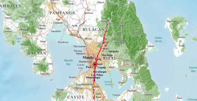
Floyd Whaley, a journalist who has worked for publications such as the Los Angeles Times and New York Times, posted on Twitter a portion of a map tracing the route of the planned Mega Manila subway project.
Whaley noticed that part of the projected subway line, particularly the portion connecting the Ortigas area in Pasig to Cayetano Boulevard in Taguig, follows the West Valley Fault.
Manila's planned subway lines up quite nicely with the West Valley Fault Line, the Philippines' highest risk earthquake zone. pic.twitter.com/ft1OzCbdAz
— Floyd Whaley (@FloydWhaley) June 19, 2018
Whaley however has linked a 2017 article by cargo and trading publication Port Calls Asia on concerns about the effect the West Valley Fault may have on the subway.
According to the article, Bases Conversion and Development Authority President Vivencio Dizon gave his assurance that construction of the subway was possible, citing the subway in Tokyo that also sits on top of a fault line.
Given the go-signal in mid-2017, the Mega Manila Subway is funded by the Japanese International Cooperation Agency. It is planned to connect Mindanao Avenue in Quezon City and the Ninoy Aquino International Airport in Parañaque. The project is estimated to cost at least P355.588 billion.
Meanwhile, the West Valley Fault traverses parts of Marikina, Muntinlupa, Quezon City, Rizal, Laguna, Cavite, and Taguig. It is part of the Valley Fault System that traverses Bulacan to Laguna, stretching about 146.71 kilometers.
As of 2017, estimates of more than 6,300 structures and 2.3 million inhabitants could be affected should the Valley Fault System generate an earthquake.
In recent years, the Department of Science and Technology – Philippine Institute of Volcanology and Seismology has repeatedly warned of the West Valley Fault’s capability to generate a 7.2 magnitude earthquake.
According to Phivolcs, the West Valley Fault moves every 400 to 600 years. Its last recorded movement was in 1658, 360 years ago.
Phivolcs director Renato Solidum Jr. has advised that newer, taller buildings were more secure in the event of an earthquake, and warned that smaller, older buildings were at greater risk of sustaining damage.
Phivolcs has also released an infographic on the areas in the metropolis susceptible to liquefaction— the phenomenon where “loosely consolidated sediments of soil deposits lose their strength and appear to flow as fluids.”
Other agencies in the government have responded to warnings from the science sector. In June 2017, the Metropolitan Manila Development Authority addressed the public’s concerns about “The Big One” by holding metro-wide earthquake drills.
President Rodrigo Duterte in May 2018 signed Executive Order 52 creating the Program Management Office for Earthquake Resiliency of the Greater Metro Manila Area, addressing persisting concerns on The Big One.


