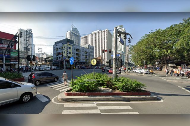
A supposed picture of a pedestrian lane in the city of Manila drew the attention of Twitter users as it leads to a central island instead of a road accessible to commuters.
Ira Cruz of AltMobility PH shared an image of the pedestrian lane that can be found at the intersection between Kalaw Avenue and Maria Orosa Street in the city.
Instead of leading to an unblocked passageway, the markers led to a triangular center island placed to intentionally reduce motorists’ speeds in the area. These are usually placed in busy areas such as intersections.
“Good morning from Manila—where pedestrian lanes lead nowhere,” Cruz tweeted with a facepalm emoji.
Good morning from Manila – where pedestrian lanes lead nowhere 🤦🏻♂️ pic.twitter.com/h9pBbM3Q4N
— ira kroos (@iracruz) June 18, 2022
His tweet has earned more than 8,700 likes as of this writing. It also earned various comments from the microblogging platform.
“That ‘refuge island’ provides no refuge for pedestrians crossing when there are (those) many misplaced plants. Dapat may part for pedestrians to stay in,” a Twitter user commented.
“Katakot tumawid,” another online user wrote.
A different Filipino tagged Manila Mayor Isko Moreno Domagoso in the comments.
“@IskoMoreno baka naman po,” he wrote.
Another Twitter user alleged that the same thing can be reportedly found in Indonesia, a neighboring country.
Indonesians can relate https://t.co/Ak49FWxcNw
— Kika (@endrizka_r) June 18, 2022
Pedestrian lanes refer to a designated space on the roadway for the exclusive use of commuters to cross streets and for them to be able to move on busy roads.
It is also found in areas where many pedestrians are always attempting to cross (such as in shopping areas) or where there are vulnerable commuters such as children.
The markers also signal drivers to exercise extra caution in anticipation of pedestrians crossing.
When combined with refuge islands, the marker is known as a “traffic calming technique” which refers to design features and strategies aimed to improve safety for motorists, pedestrians and cyclists.
Refuge islands, meanwhile, refer to walkable features in the middle of the road that are installed to make pedestrians cross safely, usually in busy streets.
Below is a sample of a refuge island in East Hollywood in the United States, as shared by Los Angeles City Council member Mitch O’Farrell.
“The pedestrian refuge island is an improvement to the existing marked crosswalk at this intersection as it now includes new ADA-compliant curbs and landing pads,” he wrote in May 2020.


