MANILA – The low pressure area located east of Luzon has intensified overnight into a tropical depression, making it the first tropical cyclone to enter the Philippine Area of Responsibility (PAR) since the onset of the wet season.
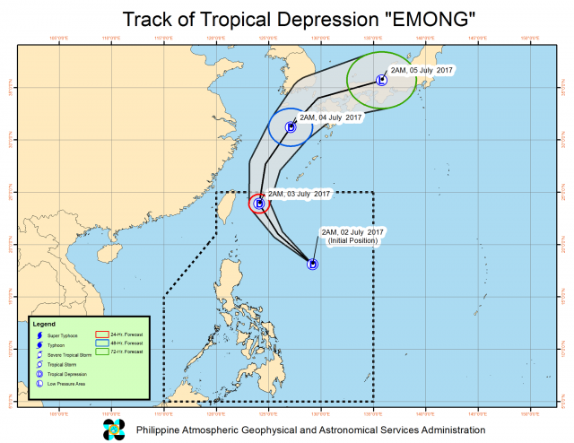
The state weather bureau on Sunday morning located tropical depression Emong at 765 kilometers east of Tuguegarao City, Cagayan with maximum sustained winds of 45 kilometers per hour near the center and gustiness of up to 60 kilometers per hour.
It is not expected to make landfall over any part of the country as it moves northwest at 30 kilometers per hour, the Philippine Atmospheric, Geophysical and Astronomical Services Administration (Pagasa) said.
However, Pagasa weather forecaster Samuel Duran said tropical cyclone warning signal may be hoisted over Batanes within the next 24 hours as Emong moves closer to the area of Taiwan.
Duran said the tropical depression has yet to directly affect any part of the Philippine archipelago, but parts of Mindanao and Visayas will continue experiencing rainy weather on Sunday as Emong draws in monsoon rains brought by the southwest monsoon or habagat.
“Cloudy skies with light to moderate rainshowers and thunderstorms will be experienced over the regions of Western Visayas, Negros Island, Caraga, Davao and Soccsksargen,” Pagasa said in its 5 a.m. weather forecast.
Pagasa does not expect Emong to further intensify into a tropical storm before moving out of PAR on Monday.
Emong is the fifth tropical cyclone to enter PAR this year; the last was tropical storm Dante in April.


