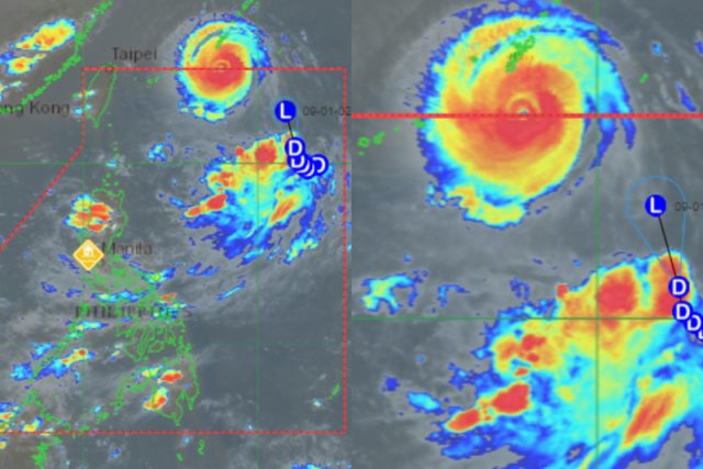
Entering the Philippine Area of Responsibility (PAR) is different from making landfall.
A meteorologist and a science page pointed this out on social media amid the public’s fears over the possible impact of Super Typhoon “Henry” (international name: Hinnamnor) on the country.
The Joint Typhoon Warning Center (JTWC) classified Hinnamnor as a “Category 5 Storm” with maximum sustained winds of 260 kilometers per hour and gustiness of 315 kph.
The Philippine Atmospheric, Geophysical and Astronomical Services Administration (PAGASA) also labeled it as a “Super Typhoon” after it developed outside of PAR.
In an update, the state weather bureau said that Henry entered PAR at 5:30 p.m. today, on August 31.
News about a new strong tropical cyclone made several social media users worried about the possible damages that it will inflict on the affected areas.
ABS-CBN News resident meteorologist Ariel Rojas informed the public on August 30 that both tropical depression “Gardo” and Hinnamnor will not make landfall, thus not directly affecting the country.
“Both #GardoPH and #Hinnamnor are nonlandfalling and will not directly affect the country. TD Gardo will eventually merge with the circulation of STY Hinnamnor, which will be called #HenryPH once inside PAR,” Rojas said.
Both #GardoPH and #Hinnamnor are nonlandfalling and will not directly affect the country. TD Gardo will eventually merge with the circulation of STY Hinnamnor, which will be called #HenryPH once inside PAR. pic.twitter.com/4TuwoiUWYH
— Ariel Rojas (@arielrojasPH) August 30, 2022
Later, in a new tweet on August 31, Rojas told the public that the current rainfall in some parts of the country is not caused by a tropical cyclone.
“Reminder lang na nasa (at mananatili sa) gitna ng dagat sina #GardoPH at #Hinnamnor. Hindi po bagyo ang nagpapaulan dito sa Metro Manila, Zambales, at Bataan,” he said.
Similarly, a science page called “Science Konek” explained that entering the PAR does not mean a tropical cyclone will make landfall.
“Papasok ang bagyong #Hinnamnor sa PAR mamaya, pero HINDI ibig sabihin ay ‘stormy’ weather na agad sa Pilipinas at HINDI rin po ibig sabihin ay mag-lalandfall na ito,” the page said.
It used a sentimental or “hugot” experience for a relatable analogy.
“Parang sa buhay, hindi lahat ng pumapasok sa buhay mo’y sa iyo dumidiretso,” Science Konek said.
ENTERS PAR =/= HITTING PH⚠️
Papasok ang bagyong #Hinnamnor sa PAR mamaya, pero HINDI ibig sabihin ay “stormy” weather na agad sa Pilipinas at HINDI rin po ibig sabihin ay mag-lalandfall na ito.
Parang sa buhay, hindi lahat ng pumapasok sa buhay mo’y sa iyo dumidiretso. pic.twitter.com/afR9SYdGQd
— ScienceKonek (@sciencekonek) August 31, 2022
“Depende sa lawak at kung saan galing ang bagyo, kadalasan ay hindi agad nararamdaman ang direktang epekto nito sa bansa pagpasok sa loob ng Philippine Area of Responsibility dahil ang boundary ay may kalayuan sa kapuluan,” the page said.
“Sa kaso ng STY #Hinnamnor, papasok mamayang gabi ang sentro ng bagyo, pero posibleng bukas pa o s Biyernes direktang maramdaman ito sa Extreme Northern Luzon. Tandaan rin na hindi lahat ng halos 20 bagyong pumapasok sa PAR ay nag-lalandfall, ang iba’y nagrerecurve,” it added.
The National Oceanic and Atmospheric Association (NOAA) defines landfall as “the intersection of the surface center of a tropical cyclone with a coastline.”
In its glossary on weather-related terms, NOAA explained that it is possible for a tropical cyclone to be experienced over land but not directly hitting it.
“Because the strongest winds in a tropical cyclone are not located precisely at the center, it is possible for a cyclone’s strongest winds to be experienced over land even if landfall does not occur. Similarly, it is possible for a tropical cyclone to make landfall and have its strongest winds remain over the water,” it said.
RELATED: Hurricane, typhoon, cyclone, storm: Which term should we use and when?
Updates on ‘Gardo,’ ‘Henry’
In the latest weather bulletin for Gardo, PAGASA said that the tropical depression is expected to move north northwestward or northward as it interacts with Hinnamnor.
It is packed with maximum sustained winds of 55 kph near the center and gustiness of up to 70 kph.
In the latest advisory for Henry, PAGASA said that the super super typhoon is heading west southwestward at 30 kph.
“Today through tomorrow evening, the super typhoon is forecast to decelerate while tracking generally west[1]southwestward or southwestward over the sea southeast of the Ryukyu Islands,” the bureau said.


